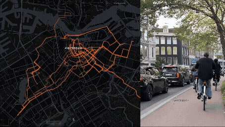
Urban Sensing

City AI

City AI

Data-technology and AI in the cityscape is outpacing plans from urban planners & architects. Countless cameras, sensors and algorithms register, analyze and control what we do, how we feel and even who we are. In the art-science installation AI INCUBATOR multi-media artist Vladimir Grafov evokes, in co-creation with architects/researchers Federica Cefis Colombo and Frank Suurenbroek, the advance of AI in the urban environment. The installation raises the question how to collaborate with this new ‘technological species’.

Public Eye

Public Eye

PublicEye is the world's first privacy by design crowd counting system that can accurately count people in public space. This open source AI was developed for UEFA Cup 2020 playoffs.

Future Fitness Garden

Future Fitness Garden

Using a AI / Computer vision solution can count the number of people using Fitness Garden and detect moments people come within 1.5m of each other.

Smart City Safari App

Smart City Safari App

Our build surrounding and digital worlds are colliding - so what is the future of architecture and urban planning in our hyper-digital era? The Smart City Safari app - reveals the many invisible layers of our city by helping you locate the many sensors in their natural habitat and how they are making smart cities like Amsterdam more responsive and resilient. Using AR (Augmented Reality) will show you technologies normally invisible to the public eye. With your own phone you’ll be able to locate the many data collecting sensors, transmitters, and many other technologies in and around you.

Social Distance Detector

Social Distance Detector

As we bounce back and forth from social isolation to social distancing, we often forget what 6ft or 1.5 meters means in our social environment. What does 1,5m meters mean back at the office or co-working space?

Smart Crowd Signs

Smart Crowd Signs

The campus is big (8 hectares), and hosts many destinations for working, learning and living spaces. The hottest days produce the largest crowds - so sharing information like events, notifications, location information and wayfinding, and data visualization is key.